| ©The Archaeological Settlements of Turkey - TAY Project | ||||||
|
|
||||||
Eskiköy Yeri |
||||||
|
|
||||||
| Ages | Maps | Photos | ||||
| Neolithic Chalcolithic IA |
 |
 |
||||
|
|
||||||
|
Type:
|
Upland Settlement | |||||
|
Altitude:
|
950 m | |||||
|
Diameter:
|
m- Direction: | |||||
|
|
||||||
|
Region:
|
Mediterranean | |||||
|
Province:
|
Antalya | |||||
|
District:
|
Korkuteli | |||||
|
Village:
|
Çomakli | |||||
|
|
||||||
|
Destruction :
|
Illicit Digging | |||||
|
|
||||||
|
TAYEx:
|
Visited - 25/6/2001 | |||||
|
|
||||||
|
Registration State:
|
For detailed registration information please refer to Turkish pages. | |||||
 |
||||||
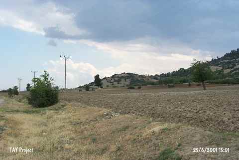
| Location: This site lies 3.6 km east of Çomakli Village; north of Korkuteli District; northwest of Antalya. |
| Geography and Environment: This mound; which lies on a natural hillock; is 35 m high and has a 60x100 m base. The settlers must have preferred this elevated terrain. The name of the site; Eskiköy Yeri; which literally means "the site near the old village"; has been given because the old village of Çomakli used to be south of this area. In addition to erosion; the site has been destroyed by treasure hunters' trenches. West of the site; along the highway between the villages of Çomakli and Bozlar; is the Eskiköy Pinari natural spring. |
| Destruction Details: The mound is being damaged due to illicit diggings. There is a rather big pit on top hill [TAYEx 25.6.2001]. |