| ©The Archaeological Settlements of Turkey - TAY Project | ||||||
|
|
||||||
Dündartepe |
||||||
|
|
||||||
| Ages | Maps | Photos | ||||
| Chalcolithic EBA |
 |
 |
||||
|
|
||||||
|
Type:
|
Mound | |||||
|
Altitude:
|
80 m | |||||
|
Diameter:
|
100 m- Direction: SE-NW | |||||
|
|
||||||
|
Region:
|
Black Sea | |||||
|
Province:
|
Samsun | |||||
|
District:
|
Merkez | |||||
|
Village:
|
Merkez | |||||
|
|
||||||
|
Destruction :
|
Agriculture - Contemporary Settlements - Highways, roads, bridges etc. - Attention | |||||
|
|
||||||
|
TAYEx:
|
Visited - 5/9/2003 | |||||
|
|
||||||
|
Registration State:
|
Registered For detailed registration information please refer to Turkish pages. | |||||
 |
||||||
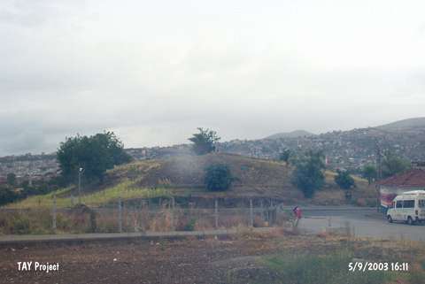
| Location: The site lies approximately 3 km southeast of Samsun; almost inside the modern city; on the slope sloping down to Merd River. |
| Geography and Environment: The 220x200 m mound was split into two by Samsun-Sivas Railway. The northern and northwestern slopes of the 15 m high mound are steep. Surrounded by gardens; the site is located in a watery area. The northern and northeastern edges of the railway fissure are high. The mound is also known as "Öksürüktepe" (Öksürükdede); because it is believed that the saint on the hill offers healing to the sick children. |
| Destruction Details: The skirts of the site have been damaged due to contemporary settlements and road construction. Its northern and western parts are being cultivated [TAYEx 5.9.2003]. |