| ©The Archaeological Settlements of Turkey - TAY Project | ||||||
|
|
||||||
Degirmenetegi Mevkii |
||||||
|
|
||||||
| Ages | Maps | Photos | ||||
| EBA |
 |
 |
||||
|
|
||||||
|
Type:
|
Mound | |||||
|
Altitude:
|
100 m | |||||
|
Diameter:
|
74 m- Direction: N-E | |||||
|
|
||||||
|
Region:
|
Marmara | |||||
|
Province:
|
Balikesir | |||||
|
District:
|
Altieylül | |||||
|
Village:
|
Aslihan | |||||
|
|
||||||
|
Destruction :
|
Illicit Digging - Agriculture - Attention | |||||
|
|
||||||
|
TAYEx:
|
Visited - 6/7/2008 | |||||
|
|
||||||
|
Registration State:
|
For detailed registration information please refer to Turkish pages. | |||||
 |
||||||
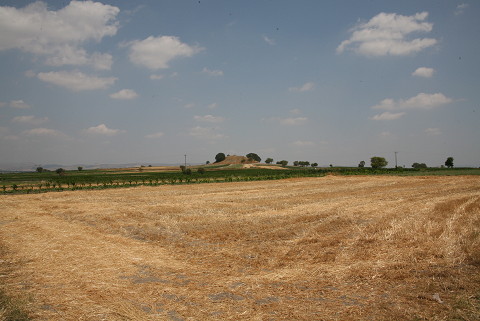
| Location: |
| Geography and Environment: |
| Destruction Details: It was visited by the team of TAYEx Bizans Marmara in July 2008. The mound was surrounded by plantation fields. There is some material found at 50 m from the mound. It is assumed that the mound covers that big of an area but it was destructed due to the presence of fields at present. The fields reached all the way up to the slopes of the mound. The presence of an illicitly dug pit was observed approximately 1.5 m deep, and 7 m in diameter on the northwest of the peak of the mound. There are also traces of illicit diggings on the southeast and northwest of the mound. Terracing seriously caused destruction on the mound [TAYEx 6.7.2008]. |