| ©The Archaeological Settlements of Turkey - TAY Project | ||||||
|
|
||||||
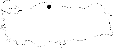
Daday Çevresi |
||||||
|
|
||||||
| Ages | Maps | Photos | ||||
| Palaeolithic/Epipalaeolithic |
 |
 |
||||
|
|
||||||
|
Type:
|
Single Findspot | |||||
|
Altitude:
|
m | |||||
|
Diameter:
|
m- Direction: | |||||
|
|
||||||
|
Region:
|
Black Sea | |||||
|
Province:
|
Kastamonu | |||||
|
District:
|
Daday | |||||
|
Village:
|
Merkez | |||||
|
|
||||||
|
|
||||||
|
|
||||||
|
TAYEx:
|
Not visited - 20/9/2003 | |||||
|
|
||||||
|
Registration State:
|
For detailed registration information please refer to Turkish pages. | |||||
 |
||||||
| Location: This site is northwest of the city of Kastamonu and south of the town of Daday; on the southern shore of the Gökirmak River. The site; according to Bostanci; is located immediately southeast of the town of Daday. |
| Geography and Environment: There are several rock-shelters with blocked entrances in this area. Some may actually be whole caves filled with soil. Based on the present day climate and vegetation; Bostanci claims that this region must have been suitable for Palaeolithic habitation. The nearby Daday Stream is an area of tectonic subsidence running east-west which has been bounded to the north and south by dike fractures. The Daday Stream represents the upper reaches of the Gökirmak River. The flat areas with alluvial deposits east and west of the stream are part of the closed basin formed in the Neogaean Period. There are wide strips of alluvial deposit along the stream banks. |
| Destruction Details: |