| ©The Archaeological Settlements of Turkey - TAY Project | ||||||
|
|
||||||
Antandros |
||||||
|
|
||||||
| Ages | Maps | Photos | ||||
| IA |
 |
 |
||||
|
|
||||||
|
Type:
|
City | |||||
|
Altitude:
|
m | |||||
|
Diameter:
|
m- Direction: | |||||
|
|
||||||
|
Region:
|
Marmara | |||||
|
Province:
|
Balikesir | |||||
|
District:
|
Altinoluk | |||||
|
Village:
|
Avcilar | |||||
|
|
||||||
|
|
||||||
|
|
||||||
|
TAYEx:
|
- | |||||
|
|
||||||
|
Registration State:
|
For detailed registration information please refer to Turkish pages. | |||||
 |
||||||
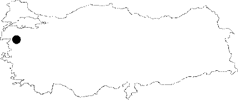
| Location: Located in the Troad Region, Antandros rests on the summit and western slopes of the Kaletasi Hill, which is 215 m high above the sea level, extending steeply into the sea, 2.5 km east of the Altinoluk Subdistrict on the southern skirts of the Mount Ida, north of the Edremit Gulf [Polat 2003:21]. |
| Geography and Environment: |
| Destruction Details: |