| ©The Archaeological Settlements of Turkey - TAY Project | ||||||
|
|
||||||
Çoban Ali Höyük |
||||||
|
|
||||||
| Ages | Maps | Photos | ||||
| Neolithic |
 |
 |
||||
|
|
||||||
|
Type:
|
Mound | |||||
|
Altitude:
|
1110 m | |||||
|
Diameter:
|
240 m- Direction: E-W | |||||
|
|
||||||
|
Region:
|
Central Anatolia | |||||
|
Province:
|
Karaman | |||||
|
District:
|
Merkez | |||||
|
Village:
|
Kisecik | |||||
|
|
||||||
|
Destruction :
|
Agriculture | |||||
|
|
||||||
|
TAYEx:
|
Visited - 17/8/2002 | |||||
|
|
||||||
|
Registration State:
|
For detailed registration information please refer to Turkish pages. | |||||
 |
||||||
| Location: This site lies southwest of both the city of Konya and the town of Karapinar. The exact location has not been reported. |
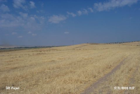
| Geography and Environment: The mound; located northeast of the volcanic Mount Karadag; is composed of two adjacent hillocks. The researchers therefore refer to the mound as Çoban Ali Höyük I and II. Watkins; in fact; believes that the mound is a single mound and that it was divided into two by water erosion. Both mounds are relatively low. |
| Destruction Details: One of the hills has been planted and the other has been damaged by DSI (State Hydraulic Works) while searching water by digging a well on top hill ten years ago [TAYEx 17.8.2002]. |