| ©The Archaeological Settlements of Turkey - TAY Project | ||||||
|
|
||||||
Çatalhöyük (East) |
||||||
|
|
||||||
| Ages | Maps | Photos | ||||
| Neolithic 14C |
 |
 |
||||
|
|
||||||
|
Type:
|
Mound | |||||
|
Altitude:
|
903 m | |||||
|
Diameter:
|
m- Direction: | |||||
|
|
||||||
|
Region:
|
Central Anatolia | |||||
|
Province:
|
Konya | |||||
|
District:
|
Çumra | |||||
|
Village:
|
Küçükköy | |||||
|
|
||||||
|
|
||||||
|
|
||||||
|
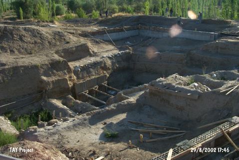
TAYEx:
|
Visited - 29/8/2002 | |||||
|
|
||||||
|
Registration State:
|
Registered For detailed registration information please refer to Turkish pages. | |||||
 |
||||||
| Location: This site lies 52 km southeast of the city of Konya and 11 km north of the town of Çumra. Of the two adjacent mounds; the eastern one was settled in the Neolithic and the western one in the Chalcolithic [Mellaart 1962e:41]. |
| Geography and Environment: Çatalhöyük is a mound 450x275 m in size; by Çarsamba Stream; which flows into the Çumra Plain. It lies 980 m above sea-level and 17.5 m above the level of the plain [Mellaart 1967a:30]. The cultural depositional fill of the mound exceeds 19 meters and is thus below the current level of the mound [Hodder 1996:44; Roberts 1991:13]. The settlement was built on the bed of the old Konya lake in an alluvial plain. The alluvial deposition which began in the beginning of the Holocene continued during the Neolithic settlement phase. Geo-archaeological studies have altered old beliefs [Cohen 1970:121-137] and confirmed that the plain was indeed different than it is now [Roberst et al. 1996:39]. The surrounding area is partially wooded. |
| Destruction Details: |