| ©The Archaeological Settlements of Turkey - TAY Project | ||||||
|
|
||||||
Çakal |
||||||
|
|
||||||
| Ages | Maps | Photos | ||||
| Chalcolithic |
 |
 |
||||
|
|
||||||
|
Type:
|
Flat Settlement | |||||
|
Altitude:
|
620 m | |||||
|
Diameter:
|
m- Direction: | |||||
|
|
||||||
|
Region:
|
Southeastern Anatolia | |||||
|
Province:
|
Adiyaman | |||||
|
District:
|
Merkez | |||||
|
Village:
|
Çakal | |||||
|
|
||||||
|
Destruction :
|
Agriculture | |||||
|
|
||||||
|
TAYEx:
|
Visited - 2/9/2001 | |||||
|
|
||||||
|
Registration State:
|
For detailed registration information please refer to Turkish pages. | |||||
 |
||||||
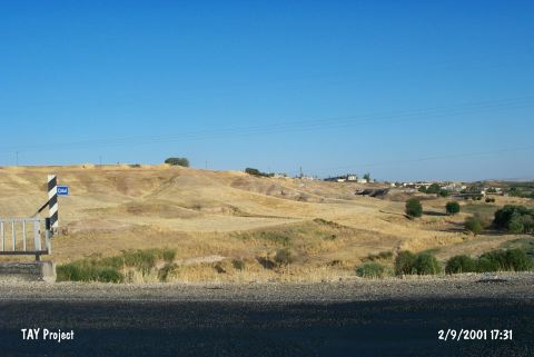
| Location: The site lies 11 km southwest of Adiyaman; near Çakal Village. It is easy to reach the site via the Adiyaman-Sambayat Road. Having no local name; the site was named as Çakal and labeled as no:39 after the survey. |
| Geography and Environment: There is no information about its dimensions and environmental features. It is most probably a plain settlement; located at the eastern slope of a narrow valley of Çakal Stream. To the north is a gushing spring; Arap Pinari. This spring and Çakal Stream; which empties into Atatürk Dam; probably met the need of water for the inhabitants. Intense ploughing caused sherds to appear on the surface. |
| Destruction Details: The find spot is being used for agricultural activities [TAYEx 2.9.2001]. |