| ©The Archaeological Settlements of Turkey - TAY Project | ||||||
|
|
||||||
Boyacioglu Çiftligi |
||||||
|
|
||||||
| Ages | Maps | Photos | ||||
| EBA IA |
 |
 |
||||
|
|
||||||
|
Type:
|
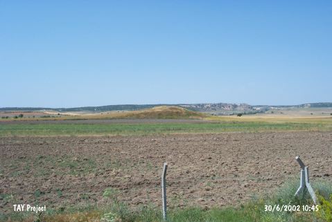
Mound | |||||
|
Altitude:
|
810 m | |||||
|
Diameter:
|
73 m- Direction: SW-NE | |||||
|
|
||||||
|
Region:
|
Central Anatolia | |||||
|
Province:
|
Eskisehir | |||||
|
District:
|
Merkez | |||||
|
Village:
|
Boyacioglu | |||||
|
|
||||||
|
Destruction :
|
Illicit Digging - Agriculture - Attention | |||||
|
|
||||||
|
TAYEx:
|
Visited - 30/6/2002 | |||||
|
|
||||||
|
Registration State:
|
Registered For detailed registration information please refer to Turkish pages. | |||||
 |
||||||
| Location: |
| Geography and Environment: |
| Destruction Details: The mound is surrounded by fields. North-northeast and northwest slopes of the mound have been cut due to extend fields. Southern slope has been planted. There is an illicit digging pit on top measuring 1.3 m in diameter and 4.6 m in depth [TAYEx 30.6.2002]. |