| ©The Archaeological Settlements of Turkey - TAY Project | ||||||
|
|
||||||
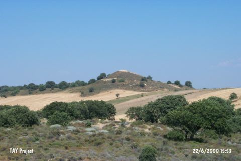
Besik - Sivritepe |
||||||
|
|
||||||
| Ages | Maps | Photos | ||||
| Chalcolithic 14C |
 |
 |
||||
|
|
||||||
|
Type:
|
Flat Settlement | |||||
|
Altitude:
|
100 m | |||||
|
Diameter:
|
m- Direction: | |||||
|
|
||||||
|
Region:
|
Marmara | |||||
|
Province:
|
Çanakkale | |||||
|
District:
|
Gelibolu | |||||
|
Village:
|
Yeniköy | |||||
|
|
||||||
|
|
||||||
|
|
||||||
|
TAYEx:
|
Visited - 22/6/2000 | |||||
|
|
||||||
|
Registration State:
|
Registered For detailed registration information please refer to Turkish pages. | |||||
 |
||||||
| Location: The site lies southwest of Çanakkale; approximately 2.1 km south-southwest of Yeniköy; northeast of Besige Cape; under the steep tumulus. |
| Geography and Environment: Besige Cape; surrounding Koca Liman (Besige Harbor) Cove from the north; is a round extension towards the Aegean Sea. It was known as Besiktepe for many years. The excavations revealed the Hellenistic Period tumulus that stands 18 m higher than sea level together with the mound and the elevation made of limestone beneath it. |
| Destruction Details: |