| ©The Archaeological Settlements of Turkey - TAY Project | ||||||
|
|
||||||
Yarikkaya |
||||||
|
|
||||||
| Ages | Maps | Photos | ||||
| Chalcolithic EBA |
 |
 |
||||
|
|
||||||
|
Type:
|
Upland Settlement | |||||
|
Altitude:
|
1010 m | |||||
|
Diameter:
|
m- Direction: | |||||
|
|
||||||
|
Region:
|
Central Anatolia | |||||
|
Province:
|
Çorum | |||||
|
District:
|
Bogazkale | |||||
|
Village:
|
Merkez | |||||
|
|
||||||
|
|
||||||
|
|
||||||
|
TAYEx:
|
Visited - 15/8/2003 | |||||
|
|
||||||
|
Registration State:
|
For detailed registration information please refer to Turkish pages. | |||||
 |
||||||
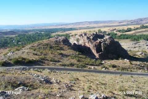
| Location: The site is located on a calcareous rocky elevation; bearing the same name; lying southwest of the city of Çorum; southeast of Sungurlu; in between the villages of Bogazköy and Emirler Köyü; 1.6 km northeast of the village of Bogazkale; 3 km southeast of the village of Yekbas; and 2 km north of Yazilikaya. |
| Geography and Environment: The location called Yarikkaya is on the natural calcareous hills located high on the eastern slopes of a valley. A steep terrace lies below; descending to the plain. The location has been named thus; since the environs have the wavy outlook of much fragmented lands. In some publications it has been misspelled as Yarikaya. The cultural deposit is approximately 2 m thick. |
| Destruction Details: |