| ©The Archaeological Settlements of Turkey - TAY Project | ||||||
|
|
||||||
Yalova / Göztepe |
||||||
|
|
||||||
| Ages | Maps | Photos | ||||
| Neolithic |
 |
 |
||||
|
|
||||||
|
Type:
|
Flat Settlement | |||||
|
Altitude:
|
40 m | |||||
|
Diameter:
|
m- Direction: | |||||
|
|
||||||
|
Region:
|
Marmara | |||||
|
Province:
|
Yalova | |||||
|
District:
|
Merkez | |||||
|
Village:
|
Samanli | |||||
|
|
||||||
|
Destruction :
|
Agriculture - Contemporary Settlements - Highways, roads, bridges etc. - Attention | |||||
|
|
||||||
|
TAYEx:
|
Visited - 18/7/2000 | |||||
|
|
||||||
|
Registration State:
|
For detailed registration information please refer to Turkish pages. | |||||
 |
||||||
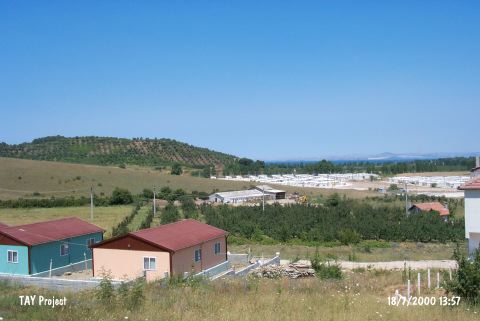
| Location: This site lies 3 km west of the city of Yalova; approximately 1 km north of the village of Samanli; on the east-northeastern extension of the Baltaçiftligi natural outcrop. |
| Geography and Environment: The site is 800 m from the Marmara Sea. Ceramic fragments were found on the field in the east-southeastern part of Göztepe; a sand dune. The site has been destroyed by sand extraction and the construction of water canals. The inhabitants of this site must have used Samanli Stream; east of Göztepe; for water. |
| Destruction Details: The southern and southeastern skirts of the settlement are being planted. A road passes from the south and there are prefabricated earthquake houses to the south of it. The skirts of the settlement have been cut by the road and the houses [TAYEx 18.7.2000]. |