| ©The Archaeological Settlements of Turkey - TAY Project | ||||||
|
|
||||||
Velican |
||||||
|
|
||||||
| Ages | Maps | Photos | ||||
| Neolithic Chalcolithic EBA IA |
 |
 |
||||
|
|
||||||
|
Type:
|
Mound | |||||
|
Altitude:
|
110 m | |||||
|
Diameter:
|
m- Direction: | |||||
|
|
||||||
|
Region:
|
Mediterranean | |||||
|
Province:
|
Adana | |||||
|
District:
|
Seyhan | |||||
|
Village:
|
Karsli | |||||
|
|
||||||
|
Destruction :
|
Dams - Illicit Digging - Attention | |||||
|
|
||||||
|
TAYEx:
|
Visited - 28/7/2001 | |||||
|
|
||||||
|
Registration State:
|
For detailed registration information please refer to Turkish pages. | |||||
 |
||||||
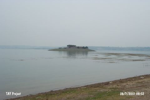
| Location: This site lies in Velican Quarter of Karsli Village; 12 km south of the city of Adana. |
| Geography and Environment: The site was lying on the western shore of the Seyhan River; at the beginning of the narrow valley created by this river before the construction of the dam. It is nearby the dam reservoir today. With the 10 m thick rock outcrop it lies on; the total height of the mound is 15-17 m. Although claimed to be the earliest settlement in the Province of Adana doubts remain. |
| Destruction Details: The mound is being damaged by the changes in the water level of dam reservoir. There are pits of illicit diggings on top hill and on skirts [TAYEx 28.7.2001]. |