| ©The Archaeological Settlements of Turkey - TAY Project | ||||||
|
|
||||||
Tekeköy |
||||||
|
|
||||||
| Ages | Maps | Photos | ||||
| EBA |
 |
 |
||||
|
|
||||||
|
Type:
|
Flat Settlement and Cemetery | |||||
|
Altitude:
|
70 m | |||||
|
Diameter:
|
m- Direction: | |||||
|
|
||||||
|
Region:
|
Black Sea | |||||
|
Province:
|
Samsun | |||||
|
District:
|
Merkez | |||||
|
Village:
|
Tekeköy | |||||
|
|
||||||
|
Destruction :
|
Agriculture - Contemporary Settlements | |||||
|
|
||||||
|
TAYEx:
|
Visited - 6/9/2003 | |||||
|
|
||||||
|
Registration State:
|
For detailed registration information please refer to Turkish pages. | |||||
 |
||||||
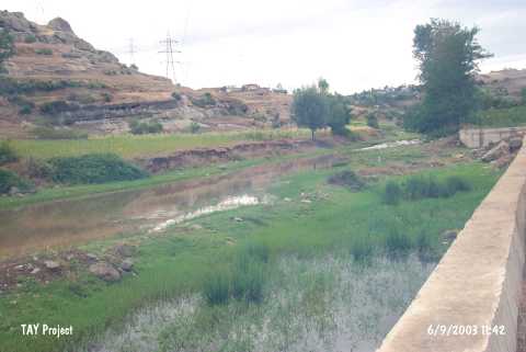
| Location: It lies in the valley of Findicak extending from the village known as Tekeköy or Tekkeköy to the south; on the south of the railway and motorway between Samsun and Çarsamba; about 16 km southeast of the Samsun Province. Being named after the nearest village; the exact location of this flat settlement and cemetery is not well defined in the publications; it is only said that it is located where two narrow valleys; getting narrower toward the south; 300 m far from a Cave "A" controlled again by a small sounding; join and start to widen [Kökten et al.1945:383]. At present; Tekeköy became a quarter of Samsun and lost its village structure with the apartments built. This modern settlement is expected to expand through the valley in a near future. The settlement is surrounded by steep rocks on the east and southeast. |
| Geography and Environment: There are a lot of rock shelters and caves on the ridges of the valley irrigated by the Findicak and Çinarlik streams. The terraces in front of the shelters on volcanic rocks look suitable for settlement. The settlement located on one of these terraces or slopes attracted the attention by its pottery finds. It is reported that the site was employed as a tobacco field; 100x50 m in dimensions during the excavation [Özgüç 1948:56]. It is surrounded by steep rocks on the east and southeast. |
| Destruction Details: The mound has been damaged due to agricultural activities and the contemporary settlement [TAYEx 6.9.2003]. |