| ©The Archaeological Settlements of Turkey - TAY Project | ||||||
|
|
||||||
Taskun Kale |
||||||
|
|
||||||
| Ages | Maps | Photos | ||||
| EBA |
 |
 |
||||
|
|
||||||
|
Type:
|
Mound | |||||
|
Altitude:
|
830 m | |||||
|
Diameter:
|
m- Direction: | |||||
|
|
||||||
|
Region:
|
Eastern Anatolia | |||||
|
Province:
|
Elazig | |||||
|
District:
|
Merkez | |||||
|
Village:
|
Muratcik | |||||
|
|
||||||
|
Destruction :
|
Dams - Attention | |||||
|
|
||||||
|
TAYEx:
|
Visited - 14/7/2003 | |||||
|
|
||||||
|
Registration State:
|
For detailed registration information please refer to Turkish pages. | |||||
 |
||||||
| Location: It was some 8-9 km far from the Balibey Village; 4 km southeast of Asvan (submerged at present); 31 km northwest of the Elazig Province as the crow flies [French 1973:fig.3]. It is coded under N 52 / 2. |
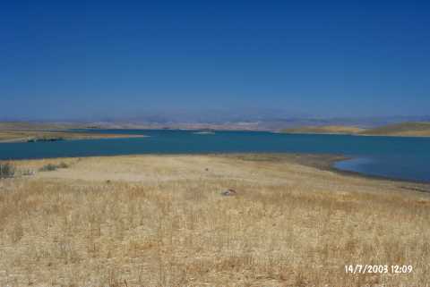
| Geography and Environment: It was located on the western bank of the Kuruçay Stream; a seasonal one; at the end of the Taskin Valley of the Euphrates. It was one of the biggest mounds of the region. It measured 20 m in height and 150 m in diameter. The mound has been influenced by the lake due to the upper water collection level of the dam. At present; it can be seen like an island from time to time. The eastern and northern slopes had terraces [McNicoll 1973:fig.1-2; Whallon 1979:164-165; fig.61; Sagona 1984:262]. To the south; there were two fresh water springs. |
| Destruction Details: The mound is flooded by dam reservoir [TAYEx 14.7.2003]. |