| ©The Archaeological Settlements of Turkey - TAY Project | ||||||
|
|
||||||
SAK Magaralari |
||||||
|
|
||||||
| Ages | Maps | Photos | ||||
| Palaeolithic/Epipalaeolithic |
 |
 |
||||
|
|
||||||
|
Type:
|
Cave | |||||
|
Altitude:
|
m | |||||
|
Diameter:
|
m- Direction: | |||||
|
|
||||||
|
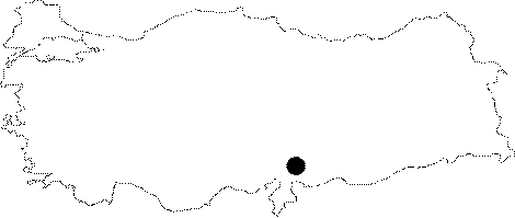
Region:
|
Mediterranean | |||||
|
Province:
|
Gaziantep | |||||
|
District:
|
Islahiye | |||||
|
Village:
|
Sakçagözü | |||||
|
|
||||||
|
|
||||||
|
|
||||||
|
TAYEx:
|
Not visited - 27/8/2001 | |||||
|
|
||||||
|
Registration State:
|
For detailed registration information please refer to Turkish pages. | |||||
 |
||||||
| Location: There are a collection of several caves and rock-shelters northwest of the city of Gaziantep; between 2 and 9 km northeast of the village of Sakçagözü. Some of the caves can be reached via the village road that goes to Kütükoba/Kötüoba and Emirler by way of Sakçagözü. The caves have been identified with numbers following the letters SAK; abbreviation for Sakçagözü. SAK 1-3 lie in the Kütükoba rock-outcrop; 3.5 km from the village while SAK 6-9 are at the foot of the graveyard. SAK 10-13 and 19 are located approximately 9 km northeast; and SAK 16 is 5 km northeast of the village. The possible Lower Palaeolithic habitation site; SAK 17; lies 2 km northwest of the village. |
| Geography and Environment: Sakçagözü is rich in flintstone sources; caves and rock-shelters because the region is karstic. The 1995 survey of the region yielded a total of 11 caves and rock-shelters. These cavities; which are between 700 and 1;100 m above sea level; face west and northwest. The entrances vary between 4 and 20 m in height; and the internal cave areas are between 50 and 250 square-meters. While some of the caves are on the terrace beneath the village graveyard; others are in the rocky region between Kütükoba and the Gaziantep border; by the Emiler; Satirhöyük and Kütükoba rock-outcrops. |
| Destruction Details: |