| ©The Archaeological Settlements of Turkey - TAY Project | ||||||
|
|
||||||
Polatli |
||||||
|
|
||||||
| Ages | Maps | Photos | ||||
| EBA |
 |
 |
||||
|
|
||||||
|
Type:
|
Mound | |||||
|
Altitude:
|
865 m | |||||
|
Diameter:
|
m- Direction: | |||||
|
|
||||||
|
Region:
|
Central Anatolia | |||||
|
Province:
|
Ankara | |||||
|
District:
|
Polatli | |||||
|
Village:
|
Merkez | |||||
|
|
||||||
|
Destruction :
|
Contemporary Settlements - Attention | |||||
|
|
||||||
|
TAYEx:
|
Visited - 4/7/2002 | |||||
|
|
||||||
|
Registration State:
|
Registered For detailed registration information please refer to Turkish pages. | |||||
 |
||||||
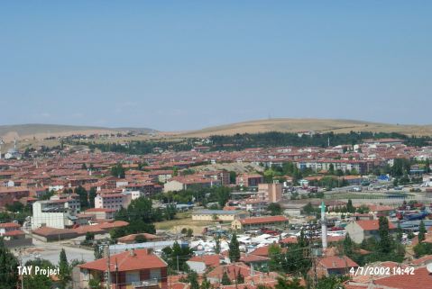
| Location: It is adjacent to the Polatli District; about 65 km southwest of the Ankara Province [Lloyd-Gökçe 1951:photograph at pl.II]. It is; probably; where it is called Zafer Höyügü. At present; it is surrounded by the modern town. |
| Geography and Environment: It has a circular shape; 25 m in height and 200 m in diameter. It has been severely damaged by the local villagers during the removal of clay earth; largely in the northern and southern sections of the mound. There is a fresh water spring nearby. |
| Destruction Details: The mound locating in downtown is seriously damaged by the buildings and roads around it; which have been constructed by cutting the skirts [TAYEx 4.7.2002]. |