| ©The Archaeological Settlements of Turkey - TAY Project | ||||||
|
|
||||||
Pazarli |
||||||
|
|
||||||
| Ages | Maps | Photos | ||||
| Chalcolithic EBA IA |
 |
 |
||||
|
|
||||||
|
Type:
|
Mound | |||||
|
Altitude:
|
1075 m | |||||
|
Diameter:
|
m- Direction: | |||||
|
|
||||||
|
Region:
|
Central Anatolia | |||||
|
Province:
|
Çorum | |||||
|
District:
|
Merkez | |||||
|
Village:
|
Çikhasan | |||||
|
|
||||||
|
|
||||||
|
|
||||||
|
TAYEx:
|
Visited - 19/7/2002 | |||||
|
|
||||||
|
Registration State:
|
For detailed registration information please refer to Turkish pages. | |||||
 |
||||||
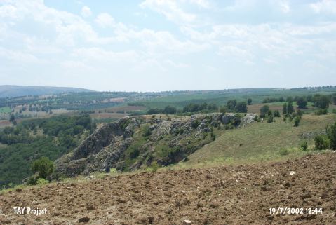
| Location: It lies at Karapinar Mevkii; between the villages of Mustafa Çelebi and Çikhasan; 1 km northeast of Çikhasan Village; south of Çorum. The site had been named as Pazarli by the excavator probably because of the former name of the village. It is locally known as Kale. |
| Geography and Environment: The settlement is surrounded by small hills pierced by streams. The natural defenses provided by the rocky block of limestone; probably; played a significant role while choosing this site for occupation. The Karapinar Özü; passing by this block; flows through a narrow strait in waterfalls and joins the Alaca River on the north. The small streams reaching this stream carved small caves by eroding the limestone rocks. At present; it is a densely wooden area. |
| Destruction Details: |