| ©The Archaeological Settlements of Turkey - TAY Project | ||||||
|
|
||||||
Oymaagaç Höyük |
||||||
|
|
||||||
| Ages | Maps | Photos | ||||
| EBA IA |
 |
 |
||||
|
|
||||||
|
Type:
|
Mound | |||||
|
Altitude:
|
285 m | |||||
|
Diameter:
|
261 m- Direction: W-E | |||||
|
|
||||||
|
Region:
|
Black Sea | |||||
|
Province:
|
Samsun | |||||
|
District:
|
Vezirköprü | |||||
|
Village:
|
Oymaagaç | |||||
|
|
||||||
|
Destruction :
|
Agriculture | |||||
|
|
||||||
|
TAYEx:
|
Visited - 17/6/2003 | |||||
|
|
||||||
|
Registration State:
|
Registered For detailed registration information please refer to Turkish pages. | |||||
 |
||||||
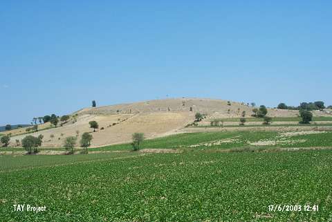
| Location: It is located 500 m west of Oymaagaç Village, about 7.5 km north-northwest of Vezirköprü District of Samsun Province. |
| Geography and Environment: The mound is located on the ancient road that begins from Central Anatolia (Bogazköy) and continues towards the Black Sea (Ikiztepe). It measures about 200x180 m and 20 m in height. It is the largest settlement of Vezirköprü Plain. It is situated in a region, which has temperate climate and fertile lands and is rich in game animals lived in nearby woodlands and close to water sources [Czichon-Yilmaz 2014:339]. |
| Destruction Details: The mound is being damaged due to agricultural activities [TAYEx 17.6.2003]. |