| ©The Archaeological Settlements of Turkey - TAY Project | ||||||
|
|
||||||
Ovabayindir |
||||||
|
|
||||||
| Ages | Maps | Photos | ||||
| EBA |
 |
 |
||||
|
|
||||||
|
Type:
|
Flat Settlement and Cemetery | |||||
|
Altitude:
|
145 m | |||||
|
Diameter:
|
m- Direction: | |||||
|
|
||||||
|
Region:
|
Marmara | |||||
|
Province:
|
Balikesir | |||||
|
District:
|
Merkez | |||||
|
Village:
|
Ovabayindir | |||||
|
|
||||||
|
Destruction :
|
Agriculture | |||||
|
|
||||||
|
TAYEx:
|
Visited - 27/6/2000 | |||||
|
|
||||||
|
Registration State:
|
For detailed registration information please refer to Turkish pages. | |||||
 |
||||||
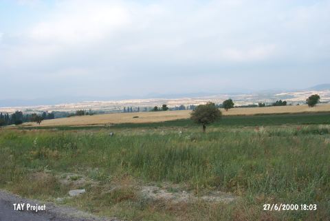
| Location: It lies at Karaagaç Tarla Mevkii; 1-2 km northeast of the Ovabayindir Village; 15 km south of Kepsut; some 20 km southeast [Bittel 1955:113] of the Balikesir Province. Although it should have been named Karaagaç Tarla; it was named after the nearest village as Ovabayindir. Some maps refer to the village as Bayindirköy. Therefore; the settlement is cited as Bayindirköy in some publications. |
| Geography and Environment: The find spot lies in the middle of a wide plain and to the north of it flows the Degirmen stream. To the south of it is the Hula Mountain and on the hills to the northwest is the village of Yenice. Ovabayindir consists of an EBA cemetery and a flat settlement near the cemetery. The area excavated is near the cemetery of the modern village. The cemetery has been severely damaged. It is noted that many of the items left as grave goods were divided to several collectors as a result of the destructions and illicit diggings. |
| Destruction Details: The find spot is damaged due to intense cultivation and illicit diggings [TAYEx 27.6.2000]. |