| ©The Archaeological Settlements of Turkey - TAY Project | ||||||
|
|
||||||
Nigde - Tepebaglari |
||||||
|
|
||||||
| Ages | Maps | Photos | ||||
| Neolithic IA |
 |
 |
||||
|
|
||||||
|
Type:
|
Mound | |||||
|
Altitude:
|
1285 m | |||||
|
Diameter:
|
m- Direction: | |||||
|
|
||||||
|
Region:
|
Central Anatolia | |||||
|
Province:
|
Nigde | |||||
|
District:
|
Merkez | |||||
|
Village:
|
Aydinyurt | |||||
|
|
||||||
|
|
||||||
|
|
||||||
|
TAYEx:
|
Visited - 9/8/2002 | |||||
|
|
||||||
|
Registration State:
|
Registered For detailed registration information please refer to Turkish pages. | |||||
 |
||||||
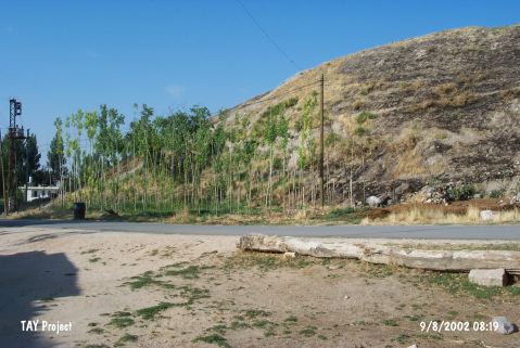
| Location: This site lies east of the mosque of Tepebag; at Tepebag Meydan street; 1 km southeast of the village of Aydinyurt (also called Fertek); which is 4 km west of the city of Nigde. It lies 1;600 m northwest of the Bor-Nigde highway. |
| Geography and Environment: The mound is 75x60 m at the base; 28 m high and lies in the orchards and vineyards west of the village of Nigde. Not to confuse the site with the other "Tepebaglari" sites; in all archaeological publications it is referred to as Nigde-Tepebaglari. The stream which springs from the southeastern part of the Melendiz Mountains flows by the village of Fertek and west of the mound. |
| Destruction Details: |