| ©The Archaeological Settlements of Turkey - TAY Project | ||||||
|
|
||||||
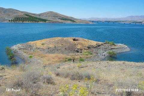
Meydancik Kale Mevkii |
||||||
|
|
||||||
| Ages | Maps | Photos | ||||
| EBA IA |
 |
 |
||||
|
|
||||||
|
Type:
|
Mound | |||||
|
Altitude:
|
645 m | |||||
|
Diameter:
|
m- Direction: | |||||
|
|
||||||
|
Region:
|
Eastern Anatolia | |||||
|
Province:
|
Malatya | |||||
|
District:
|
Battalgazi | |||||
|
Village:
|
Meydancik | |||||
|
|
||||||
|
Destruction :
|
Dams - Illicit Digging | |||||
|
|
||||||
|
TAYEx:
|
Visited - 21/7/2003 | |||||
|
|
||||||
|
Registration State:
|
For detailed registration information please refer to Turkish pages. | |||||
 |
||||||
| Location: |
| Geography and Environment: |
| Destruction Details: The dam reservoir that encircles the mound in three directions and illicit diggings damage the mound. There is a pit measuring 2.5 m in depth on top hill [TAYEx 21.7.2003]. |