| ©The Archaeological Settlements of Turkey - TAY Project | ||||||
|
|
||||||
Metmenge |
||||||
|
|
||||||
| Ages | Maps | Photos | ||||
| Palaeolithic/Epipalaeolithic |
 |
 |
||||
|
|
||||||
|
Type:
|
Single Findspot | |||||
|
Altitude:
|
920 m | |||||
|
Diameter:
|
m- Direction: | |||||
|
|
||||||
|
Region:
|
Southeastern Anatolia | |||||
|
Province:
|
Gaziantep | |||||
|
District:
|
Merkez | |||||
|
Village:
|
Köksalan | |||||
|
|
||||||
|
|
||||||
|
|
||||||
|
TAYEx:
|
Visited - 21/8/2001 | |||||
|
|
||||||
|
Registration State:
|
For detailed registration information please refer to Turkish pages. | |||||
 |
||||||
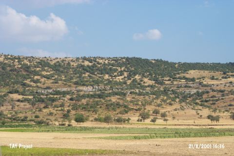
| Location: The village of Köksalan (Mertmenge) is 27 km northwest of the city of Gaziantep; and approximately 2 km northeast of the Gaziantep-Narli highway. |
| Geography and Environment: The village of Köksalan (Mertmenge) lies in a plain 870 m above sea-level and extends approximately 6 km north-south. East of the plain is 1;050 m high Mount Hik. The geological make-up of the surrounding hills northeast of the village and the adjacent areas north and west is iron rich basalt; which has caused the soil in the area to be reddish in color. There are a few caves on the flanks of Mount Hik facing the village. Another small mound mound lies 50 m north of the village. The rivers and streams in the region are seasonal. |
| Destruction Details: |