| ©The Archaeological Settlements of Turkey - TAY Project | ||||||
|
|
||||||
Merdivenli Magara |
||||||
|
|
||||||
| Ages | Maps | Photos | ||||
| Palaeolithic/Epipalaeolithic |
 |
 |
||||
|
|
||||||
|
Type:
|
Cave | |||||
|
Altitude:
|
60 m | |||||
|
Diameter:
|
m- Direction: | |||||
|
|
||||||
|
Region:
|
Mediterranean | |||||
|
Province:
|
Hatay | |||||
|
District:
|
Samandag | |||||
|
Village:
|
Magaracik | |||||
|
|
||||||
|
|
||||||
|
|
||||||
|
TAYEx:
|
Visited - 23/7/2001 | |||||
|
|
||||||
|
Registration State:
|
For detailed registration information please refer to Turkish pages. | |||||
 |
||||||
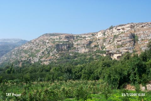
| Location: This cave site is located southwest of the city of Antakya; in the caves immediately southwest of the village of Magaracik; 4-5 km northwest of the town of Samandag. This cave does not have a local name. Senyürek and Bostanci; who discovered the site; at first called it "Cave 1" and later began referring to it as "Merdivenli Magara" which literally means "cave with steps". |
| Geography and Environment: The cave; which today is 36-39 m above sea-level; is approximately 23 m deep. 6 m wide and 2.1 m high. The entrance of the cave faces south. This cave and the other caves located on the southern flanks of Mount Musa Dag were formed in Miocene limestone. The cave ceiling as well as the eastern and western walls are covered with gritty sandstone which includes land-snail shells; fossilized mammal bones and teeth. The researchers believe that this is because the whole cave including the ceiling was submerged under the sea at one point. The west wall of the cave was quarried by the inhabitants of the city of Selevkia. At this time a staircase; which explains the name of the cave; was also carved outside the entrance |
| Destruction Details: |