| ©The Archaeological Settlements of Turkey - TAY Project | ||||||
|
|
||||||
Mercimektepe |
||||||
|
|
||||||
| Ages | Maps | Photos | ||||
| EBA |
 |
 |
||||
|
|
||||||
|
Type:
|
Mound | |||||
|
Altitude:
|
1335 m | |||||
|
Diameter:
|
m- Direction: | |||||
|
|
||||||
|
Region:
|
Central Anatolia | |||||
|
Province:
|
Yozgat | |||||
|
District:
|
Merkez | |||||
|
Village:
|
Merkez | |||||
|
|
||||||
|
Destruction :
|
Contemporary Settlements | |||||
|
|
||||||
|
TAYEx:
|
Visited - 21/7/2002 | |||||
|
|
||||||
|
Registration State:
|
Registered For detailed registration information please refer to Turkish pages. | |||||
 |
||||||
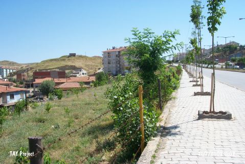
| Location: It is located immediate north of the Yozgat-Sivas motorway; 500 m east of the Yozgat Province. It is right across the Çengeltepe mound (See. Çengeltepe) |
| Geography and Environment: At present; the Yozgat-Sivas motorway runs through a gap between these two mounds. Concurrent (?) occupation of the two mounds recalls the possibility of having a big two-cored settlement. The eastern part of Mercimektepe has been destroyed by the cooperatives for mass residences while the western part was damaged by the water tank of the municipality and the piping pits. The western mound has a steep inclination towards the Yozgat Stream [Ünal 1968:120]; and covers an area of ca. 13 000 square meters [Özcan 1993:377]. |
| Destruction Details: The mound is being damaged due to contemporary settlements. There is a water reservoir on top and apartment blocks around and it is encircled by wire [TAYEx 21.7.2002]. |