| ©The Archaeological Settlements of Turkey - TAY Project | ||||||
|
|
||||||
Mentese / Yenisehir |
||||||
|
|
||||||
| Ages | Maps | Photos | ||||
| Neolithic Chalcolithic 14C |
 |
 |
||||
|
|
||||||
|
Type:
|
Mound | |||||
|
Altitude:
|
305 m | |||||
|
Diameter:
|
m- Direction: | |||||
|
|
||||||
|
Region:
|
Marmara | |||||
|
Province:
|
Bursa | |||||
|
District:
|
Yenisehir | |||||
|
Village:
|
Mentese | |||||
|
|
||||||
|
Destruction :
|
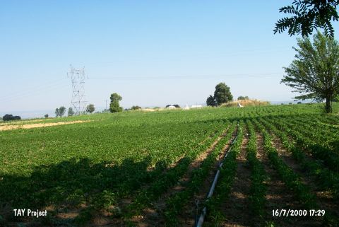
Agriculture - Contemporary Settlements - Highways, roads, bridges etc. | |||||
|
|
||||||
|
TAYEx:
|
Visited - 16/7/2000 | |||||
|
|
||||||
|
Registration State:
|
Registered For detailed registration information please refer to Turkish pages. | |||||
 |
||||||
| Location: This site lies east-northeast of the city of Bursa; 500 m southwest of the village of Mentese. |
| Geography and Environment: The mound is small and is reported to be 4x100 m in size. It has been partially blocked by the road to Selimiye. In the 1960's there was a stadia-rod on top of the mound. It is 25 km from the settlement of Ilipinar. |
| Destruction Details: The mound is surrounded by fields that continue to its skirts. Yenisehir-Selimiye road and electricity poles are also destructing the site [TAYEx 16.7.2000]. The mound is being leveled since the archaeological excavations conducted in 2000 [TAYEx 12.8.2004]. The southwestern part of the road which passes from the middle of the mound has been decreased to the level of plain [B. Dinçer. 28.4.2005]. |