| ©The Archaeological Settlements of Turkey - TAY Project | ||||||
|
|
||||||
Arslantepe |
||||||
|
|
||||||
| Ages | Maps | Photos | ||||
| Chalcolithic EBA IA 14C |
 |
 |
||||
|
|
||||||
|
Type:
|
Mound | |||||
|
Altitude:
|
830 m | |||||
|
Diameter:
|
m- Direction: | |||||
|
|
||||||
|
Region:
|
Eastern Anatolia | |||||
|
Province:
|
Malatya | |||||
|
District:
|
Merkez | |||||
|
Village:
|
Bahçebasi | |||||
|
|
||||||
|
|
||||||
|
|
||||||
|
TAYEx:
|
Visited - 21/7/2003 | |||||
|
|
||||||
|
Registration State:
|
Registered For detailed registration information please refer to Turkish pages. | |||||
 |
||||||
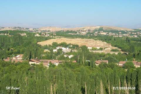
| Location: It is located at Ordüzü Mevkii; northeast of the Malatya Province. At present; Ordüzü Mevkii is a part of the city. The mound Arslantepe (Lions Hill) is named after the lions at the gate which were on the surface even before the excavation started. |
| Geography and Environment: The excavations suggested that the site had been occupied between the Chalcolithic Age and the Late Hittite Period. With its dimensions; 40 m in height and 120x200 m in size; it is one of the biggest mounds of the region. It is surrounded with gardens which are very rich in water. The abundance of water resources played an important role in selecting it as a mainland throughout the ages. It is also located on the trade route running to Central Anatolia from North Mesopotamia via Tohma Valley. |
| Destruction Details: |