| ©The Archaeological Settlements of Turkey - TAY Project | ||||||
|
|
||||||
Kürkçüler |
||||||
|
|
||||||
| Ages | Maps | Photos | ||||
| EBA IA |
 |
 |
||||
|
|
||||||
|
Type:
|
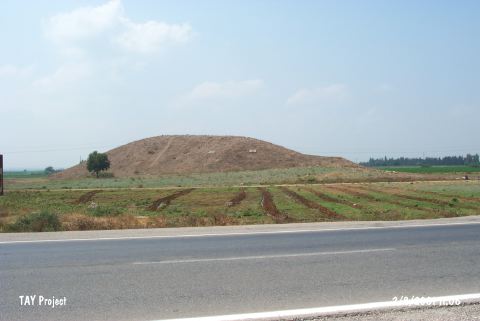
Mound | |||||
|
Altitude:
|
70 m | |||||
|
Diameter:
|
m- Direction: | |||||
|
|
||||||
|
Region:
|
Mediterranean | |||||
|
Province:
|
Adana | |||||
|
District:
|
Merkez | |||||
|
Village:
|
Merkez | |||||
|
|
||||||
|
Destruction :
|
Illicit Digging - Agriculture | |||||
|
|
||||||
|
TAYEx:
|
Visited - 2/8/2001 | |||||
|
|
||||||
|
Registration State:
|
Registered For detailed registration information please refer to Turkish pages. | |||||
 |
||||||
| Location: |
| Geography and Environment: |
| Destruction Details: The mound has been damaged due to agricultural activities and illicit diggings. Western skirt has been leveled and set for cultivation. The southern skirt is also planted. There are pits on top hill [TAYEx 2.8.2001]. |