| ©The Archaeological Settlements of Turkey - TAY Project | ||||||
|
|
||||||
Kussaray |
||||||
|
|
||||||
| Ages | Maps | Photos | ||||
| Chalcolithic EBA |
 |
 |
||||
|
|
||||||
|
Type:
|
Mound | |||||
|
Altitude:
|
1095 m | |||||
|
Diameter:
|
m- Direction: | |||||
|
|
||||||
|
Region:
|
Black Sea | |||||
|
Province:
|
Çorum | |||||
|
District:
|
Merkez | |||||
|
Village:
|
Kussaray | |||||
|
|
||||||
|
Destruction :
|
Agriculture | |||||
|
|
||||||
|
TAYEx:
|
Visited - 19/7/2002 | |||||
|
|
||||||
|
Registration State:
|
For detailed registration information please refer to Turkish pages. | |||||
 |
||||||
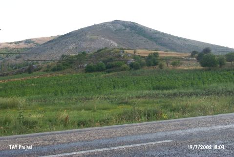
| Location: It is located in the Düvenci Plain; southwest of the Çorum-Samsun highway; between the village and the motorway; 400 m northwest of the Kussaray or Kizsaray Village; some 15 km northeast of Çorum Province. |
| Geography and Environment: It looks like a flat hill; 20-25 m high; covered by limestones. Excavation yielded a cultural deposit of ca. 4 m thick. It is suggested that a 150x100 m sized part of the hill was ringed by fortification walls. |
| Destruction Details: The mound has been damaged due to agricultural activities [TAYEx 19.7.2002]. |