| ©The Archaeological Settlements of Turkey - TAY Project | ||||||
|
|
||||||
Kocatepe |
||||||
|
|
||||||
| Ages | Maps | Photos | ||||
| Chalcolithic IA |
 |
 |
||||
|
|
||||||
|
Type:
|
Flat Settlement | |||||
|
Altitude:
|
30 m | |||||
|
Diameter:
|
m- Direction: | |||||
|
|
||||||
|
Region:
|
Marmara | |||||
|
Province:
|
Edirne | |||||
|
District:
|
Süloglu | |||||
|
Village:
|
Küküler | |||||
|
|
||||||
|
Destruction :
|
Agriculture | |||||
|
|
||||||
|
TAYEx:
|
Visited - 13/6/2000 | |||||
|
|
||||||
|
Registration State:
|
Registered For detailed registration information please refer to Turkish pages. | |||||
 |
||||||
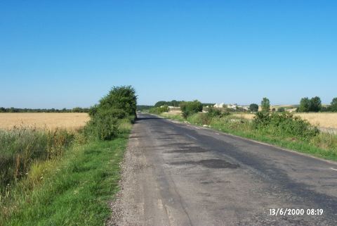
| Location: The site is located northeast of Edirne; 4 km south of the district of Süleoglu; 2 km north of the village of Küküler (previously called Gevgiler); and just west of the road from Havsa to Süloglu. |
| Geography and Environment: There are two tumuli; one named Kocatepe; on the site that elongates almost 1 km along the west bank of Süloglu Stream. The stream flows parallel to the road. |
| Destruction Details: An asphalt road passes over this flat settlement. Both sides of the road are being used as fields. On the western side; the irrigation channels running parallel to the road were also built over the settlement [TAYEx 13.6.2000]. |