| ©The Archaeological Settlements of Turkey - TAY Project | ||||||
|
|
||||||
Kocapinar |
||||||
|
|
||||||
| Ages | Maps | Photos | ||||
| Palaeolithic/Epipalaeolithic |
 |
 |
||||
|
|
||||||
|
Type:
|
Habitation Site / Workshop | |||||
|
Altitude:
|
1240 m | |||||
|
Diameter:
|
m- Direction: | |||||
|
|
||||||
|
Region:
|
Mediterranean | |||||
|
Province:
|
Antalya | |||||
|
District:
|
Elmali | |||||
|
Village:
|
Kocapinar | |||||
|
|
||||||
|
|
||||||
|
|
||||||
|
TAYEx:
|
Visited - 17/6/2001 | |||||
|
|
||||||
|
Registration State:
|
Registered For detailed registration information please refer to Turkish pages. | |||||
 |
||||||
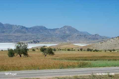
| Location: This site is located at the picnic area nearby the bridge which is 800 m southeast of Kocapinar Village; east of Elmali District of Antalya Province. |
| Geography and Environment: The site is about 1;250 m above sea level; located on a 10 m thick sandy; gravely and silty layer rich in flintstone nodules which formed at the end of the Pleistocene and the beginning of the Quaternary Periods. The extent of this open-air habitation site has not been determined. It is reported that there is another flintstone source in the nearby Gölova vicinity. This source; which yielded unusually large nodules; lies in the Tasocagi Stream Valley and on the ridges 1.5 km west of the village of Kocapinar. The Palaeolithic inhabitants of Kocapinar might have made use of this source of flint. In some publications the site is called Gölova. |
| Destruction Details: |