| ©The Archaeological Settlements of Turkey - TAY Project | ||||||
|
|
||||||
Kekerli |
||||||
|
|
||||||
| Ages | Maps | Photos | ||||
| EBA |
 |
 |
||||
|
|
||||||
|
Type:
|
Mound | |||||
|
Altitude:
|
1770 m | |||||
|
Diameter:
|
150 m- Direction: E-W | |||||
|
|
||||||
|
Region:
|
Eastern Anatolia | |||||
|
Province:
|
Mus | |||||
|
District:
|
Bulanik | |||||
|
Village:
|
Kirkgöze | |||||
|
|
||||||
|
Destruction :
|
Contemporary Settlements - Attention | |||||
|
|
||||||
|
TAYEx:
|
Visited - 8/7/2003 | |||||
|
|
||||||
|
Registration State:
|
For detailed registration information please refer to Turkish pages. | |||||
 |
||||||
| Location: |
| Geography and Environment: |
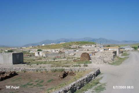
| Destruction Details: The mound has been damaged by contemporary settlement. It is being used as the cemetery area of the village and there are graves probably dated to Seljukian Period as well as the modern ones. The slopes of the mound have been damaged by the houses and an electricity pole stands on northern slope. A stone wall surrounds northeastern part [TAYEx 8.7.2003]. |