| ©The Archaeological Settlements of Turkey - TAY Project | ||||||
|
|
||||||
Keçiler Magarasi |
||||||
|
|
||||||
| Ages | Maps | Photos | ||||
| Palaeolithic/Epipalaeolithic Neolithic |
 |
 |
||||
|
|
||||||
|
Type:
|
Cave | |||||
|
Altitude:
|
740 m | |||||
|
Diameter:
|
m- Direction: | |||||
|
|
||||||
|
Region:
|
Southeastern Anatolia | |||||
|
Province:
|
Adiyaman | |||||
|
District:
|
Merkez | |||||
|
Village:
|
Pirun | |||||
|
|
||||||
|
|
||||||
|
|
||||||
|
TAYEx:
|
Visited - 26/9/2001 | |||||
|
|
||||||
|
Registration State:
|
For detailed registration information please refer to Turkish pages. | |||||
 |
||||||
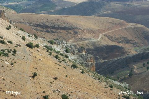
| Location: This site lies 6-7 km north-northeast of the city of Adiyaman; 3 km north of the villages of Büyük and Küçük Pirun (also known as Pirin); 2 km before arriving at the village of Palanli; directly east of the village of Gebel; in the Palanli Valley. It is possible to reach the cliff-like rock drop-off that the cave is located in via a narrow trail. The cliffs are 400 m west of the road. The construction site road; which is parallel to the stream; passes in front of the cave. |
| Geography and Environment: The cave has no local name. We have preferred to use the name "Keçiler Magarasi"; the name given to the cave by Kökten; rather than calling it the "Palanli Cave Site" as it has been referred to in ASPRO [Hours et al. 1994:267]; not to confuse the site with the nearby Palanli-Pirun Rock Shelter. The cave has two separate mouths. It is 20 m long; 5-10 m wide. The height of the cave and the thickness of the fill deposit; if there is any; has not been mentioned. For more information on the cave see Harmankaya-Tanindi 1996: Keçiler Magarasi). |
| Destruction Details: |