| ©The Archaeological Settlements of Turkey - TAY Project | ||||||
|
|
||||||
Karaoglan Mevkii |
||||||
|
|
||||||
| Ages | Maps | Photos | ||||
| EBA |
 |
 |
||||
|
|
||||||
|
Type:
|
Mound | |||||
|
Altitude:
|
1050 m | |||||
|
Diameter:
|
m- Direction: | |||||
|
|
||||||
|
Region:
|
Aegean | |||||
|
Province:
|
Afyonkarahisar | |||||
|
District:
|
Ihsaniye | |||||
|
Village:
|
Yaylabag | |||||
|
|
||||||
|
Destruction :
|
Contemporary Settlements - Attention | |||||
|
|
||||||
|
TAYEx:
|
Visited - 2/10/2000 | |||||
|
|
||||||
|
Registration State:
|
Registered For detailed registration information please refer to Turkish pages. | |||||
 |
||||||
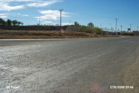
| Location: It is next to a gas station on the southeastern corner of the Gazligöl Thermal junction at some 20th km of the Afyon-Eskisehir highway; 20 km north of the Afyonkarahisar Province as the crow flies. Being on the eastern side of the highway; it is easily accessible. It was first named as Karaoglan Höyügü as it was located at Karaoglan Mevkii [Ilasli 1992:95]; then it was changed to Karaoglan Mevkii in order to prevent any confusion with Karaoglan Höyügü near Ankara. |
| Geography and Environment: It measures ca. 3 m in height above road level and 80-120 m in diameter. It is an oval; flat and wide mound. Western section revealed that the cultural deposit is not thicker than 2 m [Topbas et al. 1998:fig.15]. Virgin soil was reached at 1.2 m through a sounding opened in square N8. |
| Destruction Details: The western part of the mound was severely damaged during the construction of a gas station. The profile of the settlement can be clearly seen on the section formed by the construction. To the northwest of the mound is a village house and to the east a field [TAYEx 2.10.2000]. |