| ©The Archaeological Settlements of Turkey - TAY Project | ||||||
|
|
||||||
Karahöyük 1 |
||||||
|
|
||||||
| Ages | Maps | Photos | ||||
| Chalcolithic EBA |
 |
 |
||||
|
|
||||||
|
Type:
|
Mound | |||||
|
Altitude:
|
1115 m | |||||
|
Diameter:
|
m- Direction: | |||||
|
|
||||||
|
Region:
|
Central Anatolia | |||||
|
Province:
|
Konya | |||||
|
District:
|
Meram | |||||
|
Village:
|
Karahüyük | |||||
|
|
||||||
|
Destruction :
|
Agriculture - Highways, roads, bridges etc. - Attention | |||||
|
|
||||||
|
TAYEx:
|
Visited - 20/8/2002 | |||||
|
|
||||||
|
Registration State:
|
Registered For detailed registration information please refer to Turkish pages. | |||||
 |
||||||
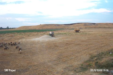
| Location: It lies some 7 km southwest of the Konya Province; situated between the motorway and the so called the Cem Gardens. This renowned mound is easily accessible. As there are more than one Karahöyük in the vicinity of Konya; this one is called No.1. |
| Geography and Environment: It is one of the highest mounds of Central Anatolia. It has ten flat hills of 4-6 m high (except one) surrounding a central tumulus. Its dimensions are reported to measure 1.000x500 m [Arik 1956:16-17; sketch 6]. It is impossible to verify the exact dimensions before removing the thick alluvium deposit it is surrounded. Achieving to reach the virgin soil at only 29.10 m in the trench C on the northern terrace proves the thickness of the deposit. To the north lie fresh water springs. The water table easily reachable by means of wells; probably; played a significant role for choosing the site as a homeland. The surface of the mound is full of holes since it was used as a military camping place for a long period of time. It has been also damaged by the local villagers due to removal of soil. |
| Destruction Details: One of the trenches remained from the archaeological excavations is filled with garbage [TAYEx 20.8.2002]. |