| ©The Archaeological Settlements of Turkey - TAY Project | ||||||
|
|
||||||
Karahasan |
||||||
|
|
||||||
| Ages | Maps | Photos | ||||
| EBA |
 |
 |
||||
|
|
||||||
|
Type:
|
Mound and Cemetery | |||||
|
Altitude:
|
680 m | |||||
|
Diameter:
|
m- Direction: | |||||
|
|
||||||
|
Region:
|
Southeastern Anatolia | |||||
|
Province:
|
Gaziantep | |||||
|
District:
|
Oguzeli | |||||
|
Village:
|
Tasli | |||||
|
|
||||||
|
Destruction :
|
Illicit Digging - Attention | |||||
|
|
||||||
|
TAYEx:
|
Visited - 19/8/2001 | |||||
|
|
||||||
|
Registration State:
|
Registered For detailed registration information please refer to Turkish pages. | |||||
 |
||||||
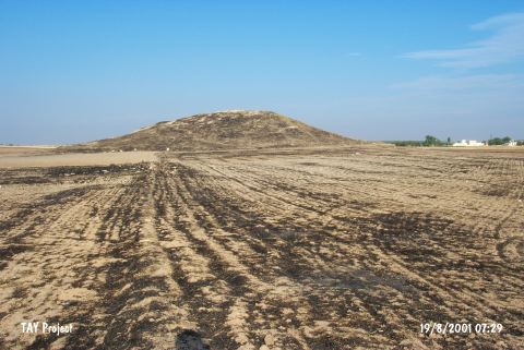
| Location: It is 200 m far from the arable fields of the Güveçli Village; some 3 km south of the village itself (Gemrik); 2 km north of the Tasli (Mukbil) Village; some 26 km southeast of the Oguzeli District; southeast of the Gaziantep Province. It was named after the site it is located; and is referred to as Tell Kara Hasan/Hassan in some publications. It can be reached via the motorway running to the south after the exit next to the Ekinveren (Tilsevet) Village on the Oguzeli road. |
| Geography and Environment: It is reported to be a flat mound measuring 10 m in height and ca. 50 m in diameter excluding the feet. It is located in the Tilbesar Plain formed by the Sacur/Secir Suyu. It was announced as a registered site by the Museum of Gaziantep. During the excavations; there was a house on the top hill and a pathway running up to that house. |
| Destruction Details: There are a lot of pits on the east slope of the mound made by illicit diggers [TAYEx 19.8.2001]. |