| ©The Archaeological Settlements of Turkey - TAY Project | ||||||
|
|
||||||
Karaaliler |
||||||
|
|
||||||
| Ages | Maps | Photos | ||||
| Neolithic Chalcolithic EBA |
 |
 |
||||
|
|
||||||
|
Type:
|
Mound | |||||
|
Altitude:
|
770 m | |||||
|
Diameter:
|
m- Direction: | |||||
|
|
||||||
|
Region:
|
Mediterranean | |||||
|
Province:
|
Burdur | |||||
|
District:
|
Bucak | |||||
|
Village:
|
Karaaliler | |||||
|
|
||||||
|
Destruction :
|
Illicit Digging - Contemporary Settlements | |||||
|
|
||||||
|
TAYEx:
|
Visited - 25/6/2001 | |||||
|
|
||||||
|
Registration State:
|
Registered For detailed registration information please refer to Turkish pages. | |||||
 |
||||||
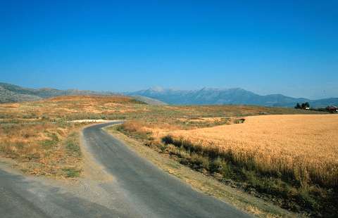
| Location: The site lies immediate east of Karaaliler Village; southwest of Bucak District of Burdur Province. |
| Geography and Environment: The site lies on the eastern side of now dried-up Kestel Lake. The real name of the site is Karaali; after the Karaali Farm. The mound is actually made up of two small adjacent mounds. |
| Destruction Details: There is an illicit digging pit measuring 5x4.5 m on top of the southern hill of the site and a house on west skirt. There are lots of pits on northern hill too [TAYEx 25.62001]. |