| ©The Archaeological Settlements of Turkey - TAY Project | ||||||
|
|
||||||
Kandilli / Bahçehisar |
||||||
|
|
||||||
| Ages | Maps | Photos | ||||
| EBA IA |
 |
 |
||||
|
|
||||||
|
Type:
|
Mound | |||||
|
Altitude:
|
820 m | |||||
|
Diameter:
|
m- Direction: | |||||
|
|
||||||
|
Region:
|
Marmara | |||||
|
Province:
|
Bilecik | |||||
|
District:
|
Bozüyük | |||||
|
Village:
|
Kandilli | |||||
|
|
||||||
|
Destruction :
|
Agriculture | |||||
|
|
||||||
|
TAYEx:
|
Visited - 19/6/2002 | |||||
|
|
||||||
|
Registration State:
|
For detailed registration information please refer to Turkish pages. | |||||
 |
||||||
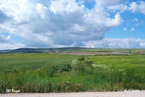
| Location: It lies 4.3 km northeast of Kandilli Village; 5 km west of Inönü; south-southeast of the Bilecik Province. |
| Geography and Environment: It is located on the western part of the Eskisehir Plain; south of Sarisu; a small branch of the Porsuk River. It is an oval hill; 7.5 m high above the plain level and 400 m long in the north-south direction. Northern part looks higher while southern part has a terrace. It was introduced as Kandilli; being named after the nearest village. However; T. Efe reports that it is locally known as Bahçehisar. It is one of the biggest mounds in the region. |
| Destruction Details: The mound is severely damaged due to agricultural activities [TAYEx 19.6.2002]. |