| ©The Archaeological Settlements of Turkey - TAY Project | ||||||
|
|
||||||
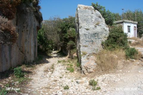
Kanal Magarasi |
||||||
|
|
||||||
| Ages | Maps | Photos | ||||
| Palaeolithic/Epipalaeolithic |
 |
 |
||||
|
|
||||||
|
Type:
|
Cave | |||||
|
Altitude:
|
30 m | |||||
|
Diameter:
|
m- Direction: | |||||
|
|
||||||
|
Region:
|
Mediterranean | |||||
|
Province:
|
Hatay | |||||
|
District:
|
Samandag | |||||
|
Village:
|
Magaracik | |||||
|
|
||||||
|
|
||||||
|
|
||||||
|
TAYEx:
|
Visited - 23/7/2001 | |||||
|
|
||||||
|
Registration State:
|
For detailed registration information please refer to Turkish pages. | |||||
 |
||||||
| Location: This cave site is southwest of the city of Antakya; northwest of the town of Samandag and very close to the village of Magaracik; on the cliffs of Mount Musa. It is approximately 500 m from the Merdivenli Cave; by the Roman water canals and lies 300 m from the Mediterranean; facing the sea. The entrance of the cave is 20 meters above sea-level. If one stands facing the cliffs from where the Roman canals reach the sea; the mouth of the cave can be spotted on the left while the base will be on the right. |
| Geography and Environment: This cave is on Mount Musa in the village of Magaracik. Palaeolithic finds were also collected from nearby caves such as Merdivenli and Ikinci. All of the caves have been carved into Helvetian limestone. Most of them are represented on a 1:100;000 map. Kanal Magarasi or "Canal Cave" was partially destroyed by canal engineers from the Roman city of Selevkia who constructed water canals around these cliffs. Much of the cave was altered beyond recognition by this activity. In fact; Minzoni-Deroche reports that this is not even a cave. We do not have exact dimensions of this cave; although we know that its mouth is small and triangular in shape. |
| Destruction Details: |