| ©The Archaeological Settlements of Turkey - TAY Project | ||||||
|
|
||||||
Alibey |
||||||
|
|
||||||
| Ages | Maps | Photos | ||||
| Chalcolithic IA |
 |
 |
||||
|
|
||||||
|
Type:
|
Mound | |||||
|
Altitude:
|
1130 m | |||||
|
Diameter:
|
m- Direction: | |||||
|
|
||||||
|
Region:
|
Central Anatolia | |||||
|
Province:
|
Konya | |||||
|
District:
|
Çumra | |||||
|
Village:
|
Alibeyhüyügü | |||||
|
|
||||||
|
Destruction :
|
Contemporary Settlements - Attention | |||||
|
|
||||||
|
TAYEx:
|
Visited - 28/8/2002 | |||||
|
|
||||||
|
Registration State:
|
Registered For detailed registration information please refer to Turkish pages. | |||||
 |
||||||
| Location: |
| Geography and Environment: |
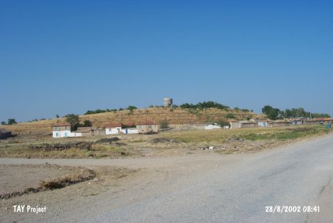
| Destruction Details: The mound has been occupied by contemporary settlement there are houses on its skirts. The water reservoir of the town stands on top hill and the cemetery is on northwest part of the mound [TAYEx 28.8.2002]. The western section of the mound is being used as a cemetery and the middle section as a green area. The trees in this area have damaged the mound [Bahar 2002]. |