| ©The Archaeological Settlements of Turkey - TAY Project | ||||||
|
|
||||||
Hunan 1 / Suboyu 1 |
||||||
|
|
||||||
| Ages | Maps | Photos | ||||
| EBA |
 |
 |
||||
|
|
||||||
|
Type:
|
Mound | |||||
|
Altitude:
|
1370 m | |||||
|
Diameter:
|
217 m- Direction: SW-NE | |||||
|
|
||||||
|
Region:
|
Eastern Anatolia | |||||
|
Province:
|
Mus | |||||
|
District:
|
Merkez | |||||
|
Village:
|
Suboyu | |||||
|
|
||||||
|
Destruction :
|
Agriculture - Contemporary Settlements - Highways, roads, bridges etc. | |||||
|
|
||||||
|
TAYEx:
|
Visited - 10/7/2003 | |||||
|
|
||||||
|
Registration State:
|
For detailed registration information please refer to Turkish pages. | |||||
 |
||||||
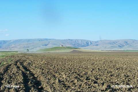
| Location: |
| Geography and Environment: |
| Destruction Details: The settlement has been damaged due to agricultural activities; contemporary settlement and road construction. There is a watchman hut on top and a dirt road starting from skirt. The southern and east-southeastern skirts have been cut in order to make way for fields. Soil has been taken from northwest section and also an illicit digging pit seen there [TAYEx 10.7.2003]. |