| ©The Archaeological Settlements of Turkey - TAY Project | ||||||
|
|
||||||
Hassanlar |
||||||
|
|
||||||
| Ages | Maps | Photos | ||||
| Neolithic EBA |
 |
 |
||||
|
|
||||||
|
Type:
|
Mound | |||||
|
Altitude:
|
1095 m | |||||
|
Diameter:
|
145 m- Direction: SE-NW | |||||
|
|
||||||
|
Region:
|
Central Anatolia | |||||
|
Province:
|
Nevsehir | |||||
|
District:
|
Hacibektas | |||||
|
Village:
|
Hasanlar | |||||
|
|
||||||
|
|
||||||
|
|
||||||
|
TAYEx:
|
Visited - 29/7/2002 | |||||
|
|
||||||
|
Registration State:
|
Registered For detailed registration information please refer to Turkish pages. | |||||
 |
||||||
| Location: This site lies at Harim/Köybolugu Mevkii; very close to the village of Hasanlar; north of Nevsehir Province. It is on the Nevsehir-Kirsehir city border. |
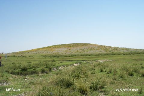
| Geography and Environment: Although the dimensions of the mound have not been provided; from the photo in the publication it is clear that the mound is middle-sized and broad mound. In Omura's publication; the site is referred to as Hassanlar; although in the map; the name of the village appears to be Hasanlar (Avanos 1:200;000). The site name chosen here is the name given by the survey director. The mound lies in the flat area known as Çerçiçölü; where Lake Seyfe is located. The inhabitants of this site could have used Kolaycik Stream as their water supply. Nearby; there is another small seasonal stream. The swamps near the mound may have functioned as hunting grounds for the inhabitants of the site. |
| Destruction Details: |