| ©The Archaeological Settlements of Turkey - TAY Project | ||||||
|
|
||||||
Harapkale |
||||||
|
|
||||||
| Ages | Maps | Photos | ||||
| EBA |
 |
 |
||||
|
|
||||||
|
Type:
|
Mound | |||||
|
Altitude:
|
160 m | |||||
|
Diameter:
|
m- Direction: | |||||
|
|
||||||
|
Region:
|
Marmara | |||||
|
Province:
|
Çanakkale | |||||
|
District:
|
Merkez | |||||
|
Village:
|
Intepe | |||||
|
|
||||||
|
Destruction :
|
Agriculture | |||||
|
|
||||||
|
TAYEx:
|
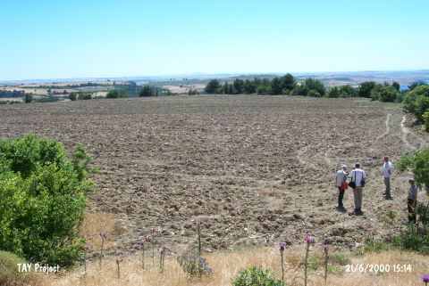
Visited - 21/6/2000 | |||||
|
|
||||||
|
Registration State:
|
For detailed registration information please refer to Turkish pages. | |||||
 |
||||||
| Location: |
| Geography and Environment: |
| Destruction Details: The settlement is seriously damaged by agricultural activities. The surface of the mound is almost completely leveled by plowing. There are illicit pits on the remains of the castle to the east. The walls of the castle are damaged by the reuse of their stones [TAYEx 21.6.2000]. During the survey carried out by R. Aslan and F. Polat in 2011, five deep illicit digging pits (which were opened a couple of months ago) were seen on the hill [Aslan-Polat 2013:8]. |