| ©The Archaeological Settlements of Turkey - TAY Project | ||||||
|
|
||||||
Hacinebi Mezarligi |
||||||
|
|
||||||
| Ages | Maps | Photos | ||||
| EBA |
 |
 |
||||
|
|
||||||
|
Type:
|
Mound | |||||
|
Altitude:
|
490 m | |||||
|
Diameter:
|
m- Direction: | |||||
|
|
||||||
|
Region:
|
Southeastern Anatolia | |||||
|
Province:
|
Sanliurfa | |||||
|
District:
|
Birecik | |||||
|
Village:
|
Ugurcuk | |||||
|
|
||||||
|
Destruction :
|
Agriculture - Contemporary Settlements - Attention | |||||
|
|
||||||
|
TAYEx:
|
Visited - 16/8/2001 | |||||
|
|
||||||
|
Registration State:
|
For detailed registration information please refer to Turkish pages. | |||||
 |
||||||
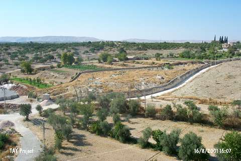
| Location: It is located next to Ugurcuk (Hacinebi) Village; 5 km north of the Birecik District; northwest of the Sanliurfa Province. |
| Geography and Environment: It is located in a very suitable place; that can be crossed by walk or a small boat; on the eastern bank of the Euphrates; besides being on the river's trade route in the north-south direction (For details; see Harmankaya et al. 1998:Hacinebi). |
| Destruction Details: The mound is remained as a low hill; the eastern part is covered by village cemetery and the western part is being used for agricultural activities [TAYEx 16.8.2001]. |