| ©The Archaeological Settlements of Turkey - TAY Project | ||||||
|
|
||||||
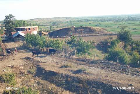
Hacibaba Tepesi 1 |
||||||
|
|
||||||
| Ages | Maps | Photos | ||||
| EBA IA |
 |
 |
||||
|
|
||||||
|
Type:
|
Mound | |||||
|
Altitude:
|
190 m | |||||
|
Diameter:
|
50 m- Direction: E-W | |||||
|
|
||||||
|
Region:
|
Black Sea | |||||
|
Province:
|
Samsun | |||||
|
District:
|
Bafra | |||||
|
Village:
|
Hidirellez | |||||
|
|
||||||
|
Destruction :
|
Agriculture - Contemporary Settlements - Highways, roads, bridges etc. - Attention | |||||
|
|
||||||
|
TAYEx:
|
Visited - 9/9/2003 | |||||
|
|
||||||
|
Registration State:
|
Registered For detailed registration information please refer to Turkish pages. | |||||
 |
||||||
| Location: |
| Geography and Environment: |
| Destruction Details: The settlement has been severely damaged. The mound's soil was removed for agriculture and road construction. The village road passes from the south-southwest of it. Houses were built on the skirt and surroundings of the site [TAYEx 9.9.2003]. |