| ©The Archaeological Settlements of Turkey - TAY Project | ||||||
|
|
||||||
Habibusagi Kale |
||||||
|
|
||||||
| Ages | Maps | Photos | ||||
| EBA IA |
 |
 |
||||
|
|
||||||
|
Type:
|
Mound | |||||
|
Altitude:
|
710 m | |||||
|
Diameter:
|
m- Direction: | |||||
|
|
||||||
|
Region:
|
Eastern Anatolia | |||||
|
Province:
|
Elazig | |||||
|
District:
|
Baskil | |||||
|
Village:
|
Habibusagi | |||||
|
|
||||||
|
Destruction :
|
Dams | |||||
|
|
||||||
|
TAYEx:
|
Visited - 18/7/2003 | |||||
|
|
||||||
|
Registration State:
|
For detailed registration information please refer to Turkish pages. | |||||
 |
||||||
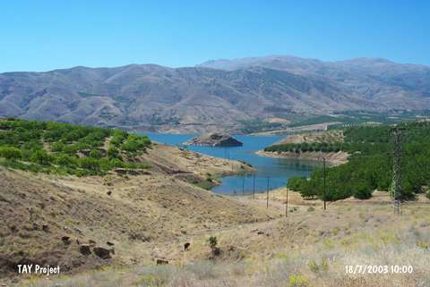
| Location: Kalenin dört bir yanı sarp kalker kayalıklarıyla çevrelenmiştir. Denizden yüksekliği 713 m'dir. Fırat Nehri'nin geçit verdiği noktaya yakınlığı ve kuzeydoğusundaki verimli vadiye olan hakimiyeti, kalenin stratejik önemini artırmaktadır. Günümüzde Karakaya Baraj Gölü'nün suları altında kalmıştır. |
| Geography and Environment: All four sides of the fortress were encircled with steep calcareous rocks. Its altitude is. Its closeness to Euphrates River passage point and its dominance on the abundant northeast valley, makes the fortress strategically even more important. At present it is under water inside the reservoir of Karakaya Dam. |
| Destruction Details: The mound is remained as an island surrounded by dam reservoir. The villagers told that the top hill has been damaged by illicit diggings [TAYEx 18.7.2003]. |