| ©The Archaeological Settlements of Turkey - TAY Project | ||||||
|
|
||||||
Güzeloba |
||||||
|
|
||||||
| Ages | Maps | Photos | ||||
| Palaeolithic/Epipalaeolithic |
 |
 |
||||
|
|
||||||
|
Type:
|
Rock Shelter | |||||
|
Altitude:
|
10 m | |||||
|
Diameter:
|
m- Direction: | |||||
|
|
||||||
|
Region:
|
Mediterranean | |||||
|
Province:
|
Antalya | |||||
|
District:
|
Aksu | |||||
|
Village:
|
Güzeloba | |||||
|
|
||||||
|
Destruction :
|
Illicit Digging - Agriculture - Attention | |||||
|
|
||||||
|
TAYEx:
|
Visited - 22/6/2001 | |||||
|
|
||||||
|
Registration State:
|
Registered For detailed registration information please refer to Turkish pages. | |||||
 |
||||||
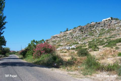
| Location: This rock-shelter is one of many (Direkli being the largest) on the Mediterranean shore east of Antalya. It lies south of the town of Aksu and 3-4 km east of the village of Güzeloba. Because of its close proximity to the Aksu Stream; in archaeological publications the site is often called the "Aksu Valley" site. |
| Geography and Environment: Rock-shelters are lined up in the upper travertine steps above the alluvial flatlands along the shore; north of the Lara (or Altinkum) beach. The rock-shelters were probably carved by spring waters when the travertine formed. It is thought that the settlers in these rock-shelters made use of the flint carried by the Aksu Stream. The Aksu Stream originates from springs on Mount Akdag and Mount Davras near Isparta and is fed by additional small springs from the Taurus Mountains before it flows east of the city of Antalya and forcefully empties into the Mediterranean Sea by the Lama beach. This stream which flows year-round; regardless of season; must have been an important water supply for those who settled along it. |
| Destruction Details: There three pits of illicit diggings at the entrance of the cave [TAYEx 22.6.2001]. |