|
©The Archaeological Settlements of Turkey - TAY Project
|
|
|
|
|
|
Firaktin |
|
|
For site maps and drawings please click on the picture...  |
For photographs please click on the photo... 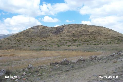 |
|
Type:
|
Mound |
|
Altitude:
|
1320 m |
|
Region:
|
Central Anatolia |
|
Province:
|
Kayseri |
|
District:
|
Develi |
|
Village:
|
Gümüsören |
|
Investigation Method:
|
Survey |
|
Period:
|
|
|
|
|
 |
|
| It is located a little far from the river; 3 km south of Gümüşören (Firaktin) Village; southeast of Develi District and Kayseri Province. A big pit was opened during an illicit digging in 1954. The conic mound measures 14 m in height and 100x90 m in dimensions. It was visited by J. M. Brown in 1965; and defined as Fahreddin by K. Bittel who discovered the site. It is renown by a relief from the Hittite Period. The flat settlement next to the mound was excavated under T. Özgüç (See Firaktin Flat Settlement). The relation between the mound and the settlement was not clearly found out; therefore they were regarded as separate sites. Further investigation is necessary. The plain and metallic (?) ware of EBA as well as the red ware of the Karum Period; the Iron Age and the Roman Period was recovered. It takes place in the registered archaeological sites list prepared by Ministry of Culture and Tourism. |
| Location: |
| Geography and Environment: |
| History: |
| Research and Excavation: |
| Stratigraphy: |
| Small Finds: |
| Remains: |
| Interpretation and Dating: |