|
©The Archaeological Settlements of Turkey - TAY Project
|
|
|
|
|
|
Evliya Tepesi |
|
|
For site maps and drawings please click on the picture...  |
For photographs please click on the photo... 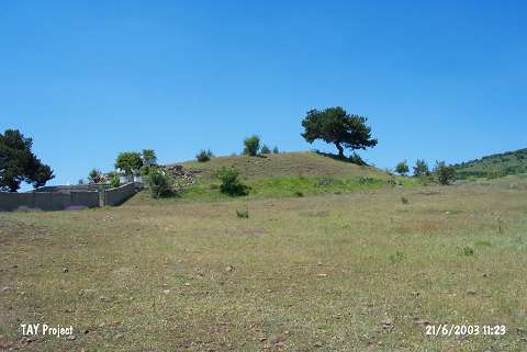 |
|
Type:
|
Mound |
|
Altitude:
|
1290 m |
|
Region:
|
Black Sea |
|
Province:
|
Ordu |
|
District:
|
Mesudiye |
|
Village:
|
Erikköy |
|
Investigation Method:
|
Survey |
|
Period:
|
|
|
|
|
 |
|
| It is located at Evliya Tepesi Mevkii; 500 m southwest of Erik Köyü; 20 km northwest of Mesudiye District of Ordu Province. It is in Evliya Tepesi Mevkii; some 1.2 km southwest of the village. To the east-northeast is the cemetery of Erik Village and to the southwest Tavuk Plateau. It was discovered during the 1993 Ordu-Mesudiye survey conducted by Mehmet Özsait. It measures 15 m in height and 70x90 m in dimensions. It stands on a natural ridge. The southern part has been damaged by the Yuyucak Stream. The surface finds strongly expose the presence of an EBA settlement. Some of the pottery recovered date back to the Late Chalcolithic Age. |
| Location: |
| Geography and Environment: |
| History: |
| Research and Excavation: |
| Stratigraphy: |
| Small Finds: |
| Remains: |
| Interpretation and Dating: |