|
©The Archaeological Settlements of Turkey - TAY Project
|
|
|
|
|
|
Bahçehisar |
|
|
For site maps and drawings please click on the picture...  |
For photographs please click on the photo... 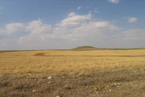 |
|
Type:
|
Mound |
|
Altitude:
|
1085 m |
|
Region:
|
Central Anatolia |
|
Province:
|
Konya |
|
District:
|
Kulu |
|
Village:
|
Bahçehisar Yaylasi |
|
Investigation Method:
|
Survey |
|
Period:
|
|
|
|
|
 |
|
| It lies approximately 7.7 km south of Kulu within the borders of the Bahçehisar Village in the Kulu District of Konya. It was discovered during the Central Anatolian Survey conducted by S. Omura in 1992. The mound measures around 100 m in north-south, and 105 m in east-west directions, with a height of 8 m. It was founded on a natural elevation. Traces of illicit diggings are observed. There are a few bases of column in marble on the southern slope. Sherds collected from the surface belong to the EBA, MBA, LBA and Iron Age. Also found are many sherds dating to the second half of the 1st Millennium BC. It takes place in the registered archaeological sites list prepared by Ministry of Culture and Tourism. |
| Location: |
| Geography and Environment: |
| History: |
| Research and Excavation: |
| Stratigraphy: |
| Small Finds: |
| Remains: |
| Interpretation and Dating: |